
Fort of Hansi
(Iron grill at the bottom is covering one of the wells of fort)
This post of mine is about a monument which has been a bone of contention for numerous rulers and invaders for several centuries. It has been a prime witness to the turmoils of our Early Medieval history. It has faced and survived numerous violent onslaughts of history. Today, centuries later, it is still fighting a battle but for its own survival and the sad news is that it is loosing this one. This time the enemy is not some invader or some expansionist ruler but the negligence of its own people.
This is a small story of a fort that was once known as an unconquerable fort but today it is dying brick by brick and is known as ruins of the fort of Hansi.
11th Century historian, Abul Fazl Bayhaqi in his ‘Tarikh-i-Mas'udi’, first mentioned it as unconquerable. He had accompanied the Ghaznavid Emperor, Mas'ud (reigned from 1030 to 1040 AD) on his campaigns in India. There must have been a very strong resistance from the defenders of the fort to earn such a title from the attackers.
As far as the history of this
fort is concerned, no one knows exactly how old it is, but from coins,
idols and other artefacts found here during the excavations of January 2004, it
is now believed to be older than the previously thought Rajput period.
(For list of items found during 2004 excavations consult- p21, “Itihaas
ki Darohar: Hansi” by Sh. Jagdish Saini, 2005)
Presence of sites belonging to
the period of Indus Valley Civilization, nearby have also raised the possibility
of its being even more older. Several such sites, both smaller and larger have been found
nearby, while some of them like Rakhigarhi are now known worldwide but others such
as the mounds of Ghirai, Kharad, Daipal, Sultanpur, Pali etc have largely remained
invisible. All these sites are located within 30 km distance of Hansi.
Try google map and you will find
that the fort is rectangular in shape with extensions on four corners. Present day fort is the result of hundreds of years of construction-demolition-reconstruction
cycle. It is believed that originally the fort was built on a solid mound of Earth
which was smaller than the total area now occupied by it.As per the views of several
people including local historian, Sh. Jagdish Saini, this fort seems to have
been expanded and raised several times by successive dynasties during the
course of history.


Eastern side of the fort
According to an inscription found here
in 1815, this fort was under the authority of King Prithviraja during 12th
century (Read more about this inscription
in the post Grand Barsi Gate of Hansi) but by the end of this century it had come under the Islamic influence.
In 14th century, a young traveller passed through the city gates. This 30 year old Moroccan adventurer was then travelling around the world for last 9 years and when he reached Hansi in the year of 1334, following an ancient trade route connecting the cities like Multan and Delhi, it was already a prosperous and well built city. Ibn Batuta later left behind the following account of the city of Hansi in his 'Rihla'-
“It is one of the best, strongest
and most prosperous of cities. It has mighty fortifications, and they say that
its builder was one of the greatest of the (belonging to other religion) kings
of India and there are many legends connected with it.”
(Above description is taken
from a secondary source: - p83, Hisar–i-Firuza by Mehrdad and Natalie Shokoohy,
1988)
(For route taken by Ibn Batuta consult, p120, Themes in Indian History-Part 2, NCERT,2007)


Western side of the fort
Well, the time changed and with
it, the travellers… but the fort somehow managed to maintain its graceful image in their minds. Nearly 500 year after Ibn-Batuta, another young Traveller,
Captain Godfrey Charles Mundy wrote down the following lines in his diary, in
November 1828.
“The fortress of Hansi, from the
abrupt and uncommanded elevation on which it stands, presents an appearance of
great strength; and is, very early in the history of India, made honourable
mention of for its impregnability”.
(p340, A Tour in India by Captain Godfrey Mundy)
Mundy was accompanying Lord
Combermere, then the Commander-in-chief of East India Company, on his tour of military
stations in Upper Provinces and had left accounts of several cities, he passed
through during this journey.
In the grand work of Abul Fazal , Ain-i-Akbari this fort is simply mentioned as a brick fort.
(p295, Translation of Ain-i-Akbari (originally compiled by Abul Fazal in 1591) by Colonel HS Jarret, 1891)
Chalisa famine of 1783-84 had left this whole area devastated. Several nearby villages were abandoned and the city of Hansi itself was largely deserted. Later around the year 1798 when George Thomas decided to make Hansi his capital, he made several efforts to rehabilitate it. He got the city walls and the fort repaired, wells were dug and new buildings were erected on the fort.
(p132, Military Memoirs of George Thomas by William Francklin, 1805)

This Water Tank on the fort is believed to be from Thomas's period
Thomas’s reign was of very short time and was over
with the Battle of Hansi (in December 1801), against Marathas. In this battle Maratha guns had caused a great damage to this previously impenetrable fort but it was
only after a long siege and a fierce battle that Thomas agreed to
surrender the city and the fort. There are not many contemporary accounts of this battle, but in the memoirs of Lt. Col. James Skinner,who was present during this entire
siege, fighting on the Maratha side, we find the best available details of this battle.
“Thomas on his side made every
preparation to defend the fort; but in consequence of the losses he had
sustained, his men were dispirited and little to be depended on. The siege was,
however carried on with great Spirit on both sides; several sallies were made
upon our trenches, and sometimes Thomas drove us out, as others we gave him a
proper thrashing. But our battering guns produced no effect, for the fort of
Hansee being a solid mound of earth, the balls merely buried themselves in it,
without in the least shaking the rampart.”
(P230, Military Memoirs of Lieut.Col.
James Skinner, C.B. Vol.-1, by J.B. Fraser, 1851)
After the treaty of 1803 with the
Marathas(Scindhia), East India Company established its authority over this territory and this fort was beginning to be used for administrative and military purposes.
Most vivid image of the city and fort around this time, was produced by a relatively unknown but undoubtedly skilled artist Sitaram, who was accompanying and chronicling the country and the journey of East India Company’s then Governor General Marquis of Hastings in 1814-15. He drew this remarkable painting of the city which is now in the collection of British Library. Union Jack is also visible in this, on the fort.

Most vivid image of the city and fort around this time, was produced by a relatively unknown but undoubtedly skilled artist Sitaram, who was accompanying and chronicling the country and the journey of East India Company’s then Governor General Marquis of Hastings in 1814-15. He drew this remarkable painting of the city which is now in the collection of British Library. Union Jack is also visible in this, on the fort.

Sitaram's view of Hansi and its fort
(courtesy of British Library)
This fort was the headquarter of
Skinner’s Irregular Cavalry (Skinner's horse regiment) in 1828 during the visit of Captain Mundy. There is another painting of the city from around the same time by an another Indian artist, Gulam Ali
Khan, showing the Skinner Horse Regiment, engaged in battle practice with the fort of
Hansi, Barsi Gate and the cantonment, visible in the background.

Painting of Ghulam Ali Khan from 1828. Fort is visible in the background
(courtesy of National Army Museum, London)
Hansi was one of the largest
cantonments of the Company army in the region. Hurrianah Light Infantry and 4th
Irregular Cavalry were stationed here during 1857 and they revolted in the last week of May along with
people from several, nearby villages. It was only after a huge loss that the
company was finally able to re-establish its control.
In 1858 when this area was under total control, company officers all of a sudden decided to blow up this fort. As a
result several structures on the fort as well as the outer bastions which are visible in Sitaram's painting, were demolished
by using the mines. Later on, the rubble was sold in an auction!. They were using this fort for administrative purposes till then and could've continued doing so but blowing off the fort without any apparent reason raises doubt. Documents related to this activity are preserved in the Archives Department, Mini Secretariat, Hisar.
Fort was already in the neglected
state when Kaji Sarif Hussain was writing the history of the city in 1915. It remained largely a deserted place, visited only by devotees or during the fairs. In
his work ‘Tajkira-i-Hansi’, he has written about an annual fair on the fort which used to be held in the month of
March-April and was attended in large numbers by people from different faiths. Mentioned in the Hisar District Gazetteer
of 1883-84 (p30) as “Miran Sahib ka Mela”, it was also known as ‘Neje ka Mela’.
It is now again being revived after a long time since 1947. Miran Sahib's tomb is on the fort and as per the inscriptions on the tomb, it is believed that he had come here during the storming of the city by the armies of Muhammad of Ghur in 12th Century.
It is now again being revived after a long time since 1947. Miran Sahib's tomb is on the fort and as per the inscriptions on the tomb, it is believed that he had come here during the storming of the city by the armies of Muhammad of Ghur in 12th Century.
Today, if one visits this fort,
he/she’ll be delighted to see the well maintained park and people busy in their daily exercises, yoga and morning walks near the entrance but take a stroll
on the perimeter, and you'll be able to see the neglected side of it; that the rain had made several deep cuts on all sides of the fort and with every season, they are
just getting bigger and wider.

These deep cuts are now visible at several sections of the fort

Well, the bright side is that we
can peer into the fort’s past through these trenches but on a serious note this is
a matter of grave concern.
There is a small building before the main fort gate which is locally known as a stable (which in fact might have been the entrance of the fort in the past while the actual stable was also situated nearby and was in existence till late 1940s ).
Entrance of the fort is now through a arched corridor with guard rooms on
both sides. Once you reach the top, a large, sub-ground building (locally known as
‘Baradari’ which doesn't seem to be fitting) will be there to your right and a rainwater harvesting tank on your left side.


There are three wells in the fort premises; one is situated near the entrance while the other two are located inside, on the far end, opposite to the entrance.
On the northern side of the fort, you will see two very old mosques (one known as Jama Masjid and other as Moti Masjid), a serai and the Tomb of Miran Sahib (Hazarat Saiyyad Shah Niyamatulla Wali). Few graves are also there which are believed to be from late 12th century.


Baradari
(Believed to have been used as an ammunition storage room in 19th century)

Baradari from inside
On the northern side of the fort, you will see two very old mosques (one known as Jama Masjid and other as Moti Masjid), a serai and the Tomb of Miran Sahib (Hazarat Saiyyad Shah Niyamatulla Wali). Few graves are also there which are believed to be from late 12th century.

From left to right:- Serai, Jama Masjid, Moti Masjid and the Tomb of Miran Sahib
Pillars of the serai are made up
of beautifully carved stones which are believed to be the remains of buildings
existing on the fort prior to 12th century.

Several other similar stones were found during the excavations of 2004.
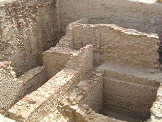
Two Sentry check posts have also
survived the onslaught of time. They are situated on the far corners of eastern and western sides.


Serai on the fort
Several other similar stones were found during the excavations of 2004.

Excavation of 2004
(Courtesy of Sh. Jagdish Saini)

One of the two surviving sentry posts (on North-Eastern corner)
In 1983, few pillars and other relics believed to be belonging to Jain
religion, were affixed on the fort.
(Source p30, “Itihaas ki Darohar:Hansi”, Sh. Jagdish Saini,2005)


Jain relics on the fort
Once completely off the limits of general public, today it is
being used for All Sorts of daily activities by people, who are either completely ignorant or perhaps not bothered by the fact that this fort has been declared as a Protected Monument of National Importance by Archeological Survey of India and there are several acts and laws for its protection. But, Alas! children are too busy playing cricket with thousand of years old pillars as wickets!
Perhaps the condition of the fort can be best described in
the words of city historian Kaji Sharif Hussain-
“Gardish-e-Jamana bhi
kya ajab Gul Khilati hai,
Tarah-Tarah ke rang
Dikhati hai;
Ek Waqt mein jahan
thakhat-e-gulaab ugaati hai,
Dusre waqt mein dekho
to Satyanasi paati hai.”
(Tajkara-i-Hansi,
1915)
(Pardon my rough English
Translation: -
"Fate creates wonders and it brings different shades.
"Fate creates wonders and it brings different shades.
Where once it flourished roses, in other times it grows weeds")
Somehow I am beginning to feel
that this article should have a dedication and it would be most suitable to dedicate it to all those who irrespective of wherever they are today, but still find themselves connected and rooted to the city of Hansi.
About Hansi:- Hansi is situated at approximately 135 Km from Delhi and 25 km from Hisar, on National Highway No.10.
Location of the Fort:- Fort is situated on the north side of the city and for reaching here, you have to pass through the oldest entrance of the city i.e. Barsi Gate, stay on this very street after crossing this gate, turn left with it and take the first right after crossing the girls school on your right.


