Friday 21 June 2013

Ruins of the fort of Hansi

Fort of Hansi
(Iron grill at the bottom is covering one of the wells of fort)

This post of mine is about a monument which has been a bone of contention for numerous rulers and invaders for several centuries. It has been a prime witness to the turmoils of our Early Medieval history. It has faced and survived numerous violent onslaughts of history. Today, centuries later, it is still fighting a battle but for its own survival and the sad news is that it is loosing this one. This time the enemy is not some invader or some expansionist ruler but the negligence of its own people. 

This is a small story of a fort that was once known as an unconquerable fort but today it is dying brick by brick and is known as ruins of the fort of Hansi.

11th Century historian, Abul Fazl Bayhaqi in his ‘Tarikh-i-Mas'udi’, first mentioned it as unconquerable. He had accompanied the Ghaznavid Emperor, Mas'ud (reigned from 1030 to 1040 AD) on his campaigns in India. There must have been a very strong resistance from the defenders of the fort to earn such a title from the attackers.

As far as the history of this fort is concerned, no one knows exactly how old it is, but from coins, idols and other artefacts found here during the excavations of January 2004, it is now believed to be older than the previously thought Rajput period.
(For list of items found during 2004 excavations consult- p21, “Itihaas ki Darohar: Hansi” by Sh. Jagdish Saini, 2005)

Presence of sites belonging to the period of Indus Valley Civilization, nearby have also raised the possibility of its being even more older. Several such sites, both smaller and larger have been found nearby, while some of them like Rakhigarhi are now known worldwide but others such as the mounds of Ghirai, Kharad, Daipal, Sultanpur, Pali etc have largely remained invisible. All these sites are located within 30 km distance of Hansi.

Try google map and you will find that the fort is rectangular in shape with extensions on four corners. Present day fort is the result of hundreds of years of construction-demolition-reconstruction cycle. It is believed that originally the fort was built on a solid mound of Earth which was smaller than the total area now occupied by it.As per the views of several people including local historian, Sh. Jagdish Saini, this fort seems to have been expanded and raised several times by successive dynasties during the course of history.


Eastern side of the fort

According to an inscription found here in 1815, this fort was under the authority of King Prithviraja during 12th century (Read more about this inscription in the post Grand Barsi Gate of Hansi) but by the end of this century it had come under the Islamic influence.

In 14th century, a young traveller passed through the city gates. This 30 year old Moroccan adventurer was then travelling around the world for last 9 years and when he reached Hansi in the year of 1334, following an ancient trade route connecting the cities like Multan and Delhi, it was already a prosperous and well built city. Ibn Batuta later left behind the following account of the city of Hansi in his 'Rihla'-

“It is one of the best, strongest and most prosperous of cities. It has mighty fortifications, and they say that its builder was one of the greatest of the (belonging to other religion) kings of India and there are many legends connected with it.”
(Above description is taken from a secondary source: - p83, Hisar–i-Firuza by Mehrdad and Natalie Shokoohy, 1988)
(For route taken by Ibn Batuta consult, p120, Themes in Indian History-Part 2, NCERT,2007)


Western side of the fort

Well, the time changed and with it, the travellers… but the fort somehow managed to maintain its graceful image in their minds. Nearly 500 year after Ibn-Batuta, another young Traveller, Captain Godfrey Charles Mundy wrote down the following lines in his diary, in November 1828.

“The fortress of Hansi, from the abrupt and uncommanded elevation on which it stands, presents an appearance of great strength; and is, very early in the history of India, made honourable mention of for its impregnability”.
(p340, A Tour in India by Captain Godfrey Mundy)

Mundy was accompanying Lord Combermere, then the Commander-in-chief of  East India Company, on his tour of military stations in Upper Provinces and had left accounts of several cities, he passed through during this journey.

In the grand work of Abul Fazal , Ain-i-Akbari this fort is simply mentioned as a brick fort.
(p295, Translation of Ain-i-Akbari (originally compiled by Abul Fazal in 1591) by Colonel HS Jarret, 1891)

Chalisa famine of 1783-84 had left this whole area devastated. Several nearby villages were abandoned and the city of Hansi itself was largely deserted. Later around the year 1798 when George Thomas decided to make Hansi his capital, he made several efforts to rehabilitate it. He got the city walls and the fort repaired, wells were dug and new buildings were erected on the fort.
                                                                      (p132, Military Memoirs of George Thomas by William Francklin, 1805)


This Water Tank on the fort is believed to be from Thomas's period

Thomas’s reign was of very short time and was over with the Battle of Hansi (in December 1801), against Marathas. In this battle Maratha guns had caused a great damage to this previously impenetrable fort but it was only after a long siege and a fierce battle that Thomas agreed to surrender the city and the fort. There are not many contemporary accounts of this battle, but in the memoirs of Lt. Col. James Skinner,who was present during this entire siege, fighting on the Maratha side, we find the best available details of this battle.

“Thomas on his side made every preparation to defend the fort; but in consequence of the losses he had sustained, his men were dispirited and little to be depended on. The siege was, however carried on with great Spirit on both sides; several sallies were made upon our trenches, and sometimes Thomas drove us out, as others we gave him a proper thrashing. But our battering guns produced no effect, for the fort of Hansee being a solid mound of earth, the balls merely buried themselves in it, without in the least shaking the rampart.” 
(P230,  Military Memoirs of Lieut.Col. James Skinner, C.B. Vol.-1, by J.B. Fraser, 1851)

After the treaty of 1803 with the Marathas(Scindhia), East India Company established its authority over this territory and this fort was beginning to be used for administrative and military purposes. 
Most vivid image of the city and fort around this time, was produced by a relatively unknown but undoubtedly skilled artist Sitaram, who was accompanying and chronicling the country and the journey of East India Company’s then Governor General Marquis of Hastings in 1814-15. He drew this remarkable painting of the city which is now in the collection of British Library. Union Jack is also visible in this, on the fort.


Sitaram's view of Hansi and its fort
(courtesy of British Library) 

This fort was the headquarter of Skinner’s Irregular Cavalry (Skinner's horse regiment) in 1828 during the visit of Captain Mundy. There is another painting of the city from around the same time by an another Indian artist, Gulam Ali Khan, showing the Skinner Horse Regiment, engaged in battle practice with the fort of Hansi, Barsi Gate and the cantonment, visible in the background.

Painting of Ghulam Ali Khan from 1828. Fort is visible in the background
(courtesy of National Army Museum, London)

Hansi was one of the largest cantonments of the Company army in the region. Hurrianah Light Infantry and 4th Irregular Cavalry were stationed here during 1857 and they revolted in the last week of May along with people from several, nearby villages. It was only after a huge loss that the company was finally able to re-establish its control.

In 1858 when this area was under total control, company officers all of a sudden decided to blow up this fort. As a result several structures on the fort as well as the outer bastions which are visible in Sitaram's painting, were demolished by using the mines. Later on, the rubble was sold in an auction!. They were using this fort for administrative purposes till then and could've continued doing so but blowing off the fort without any apparent reason raises doubt. Documents related to this activity are preserved in the Archives Department, Mini Secretariat, Hisar.

Fort was already in the neglected state when Kaji Sarif Hussain was writing the history of the city in 1915. It remained largely a deserted place, visited only by devotees or during the fairs. In his work ‘Tajkira-i-Hansi’, he has written about an annual fair on the fort which used to be held in the month of March-April and was attended in large numbers by people from different faiths. Mentioned in  the Hisar District Gazetteer of 1883-84 (p30) as “Miran Sahib ka Mela”, it was also known as ‘Neje ka Mela’. 

It is now again being revived after a long time since 1947. Miran Sahib's tomb is on the fort and as per the inscriptions on the tomb, it is believed that he had come here during the storming of the city by the armies of Muhammad of Ghur in 12th Century.

Today, if one visits this fort, he/she’ll be delighted to see the well maintained park and people busy in their daily exercises, yoga and morning walks near the entrance but take a stroll on the perimeter, and you'll be able to see the neglected side of it; that the rain had made several deep cuts on all sides of the fort and with every season, they are just getting bigger and wider.

These deep cuts are now visible at several sections of the fort

Well, the bright side is that we can peer into the fort’s past through these trenches but on a serious note this is a matter of grave concern.

There is a small building before the main fort gate which is locally known as a stable (which in fact might have been the entrance of the fort in the past while the actual stable was also situated nearby and was in existence till late 1940s ). Entrance of the fort is now through a arched corridor with guard rooms on both sides. Once you reach the top, a large, sub-ground building (locally known as ‘Baradari’ which doesn't seem to be fitting) will be there to your right and a rainwater harvesting tank on your left side.


Baradari 
(Believed to have been used as an ammunition storage room in 19th century)

Baradari from inside

There are three wells in the fort premises; one is situated near the entrance while the other two are located inside, on the far end, opposite to the entrance.

On the northern side of the fort, you will see two very old mosques (one known as Jama Masjid and other as Moti Masjid), a serai and the Tomb of Miran Sahib (Hazarat Saiyyad Shah Niyamatulla Wali). Few graves are also there which are believed to be from late 12th century.
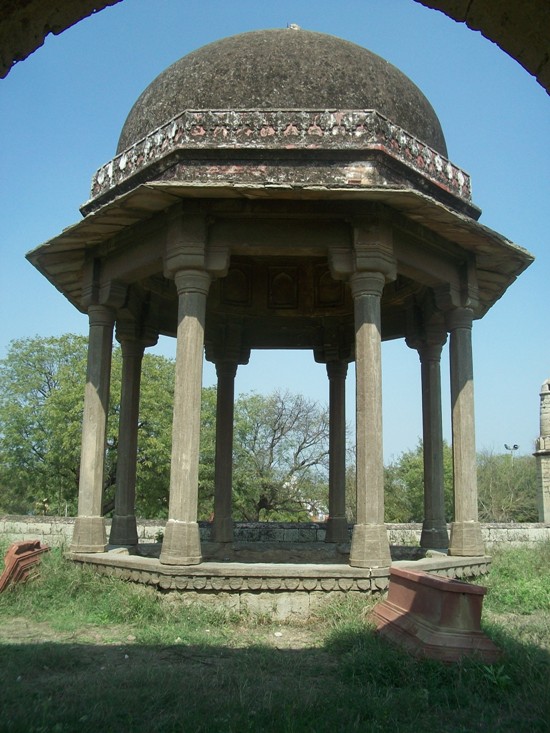

From left to right:- Serai, Jama Masjid, Moti Masjid and the Tomb of Miran Sahib

Pillars of the serai are made up of beautifully carved stones which are believed to be the remains of buildings existing on the fort prior to 12th century. 


Serai on the fort

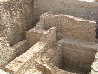
Several other similar stones were found during the excavations of 2004. 


Excavation of 2004
(Courtesy of Sh. Jagdish Saini)

Two Sentry check posts have also survived the onslaught of time. They are situated on the far corners of eastern and western sides.


One of the two surviving sentry posts (on North-Eastern corner)

In 1983, few pillars and other relics believed to be belonging to Jain religion, were affixed on the fort.
(Source p30, “Itihaas ki Darohar:Hansi”, Sh. Jagdish Saini,2005)


Jain relics on the fort

Once completely off the limits of general public, today it is being used for All Sorts of daily activities by people, who are either completely ignorant or perhaps not bothered by the fact that this fort has been declared as a Protected Monument of National Importance by Archeological Survey of India and there are several acts and laws for its protection. But, Alas! children are too busy playing cricket with thousand of years old pillars as wickets!

Perhaps the condition of the fort can be best described in the words of city historian Kaji Sharif Hussain-
“Gardish-e-Jamana bhi kya ajab Gul Khilati hai,
Tarah-Tarah ke rang Dikhati hai;
Ek Waqt mein jahan thakhat-e-gulaab ugaati hai,
Dusre waqt mein dekho to Satyanasi paati hai.”
 (Tajkara-i-Hansi, 1915)
(Pardon my rough English Translation: -
 "Fate creates wonders and it brings different shades.
Where once it flourished roses, in other times it grows weeds")

Somehow I am beginning to feel that this article should have a dedication and it would be most suitable to dedicate it to all those who irrespective of wherever they are today, but still find themselves connected and rooted to the city of Hansi.

About Hansi:- Hansi is situated at approximately 135 Km from Delhi and 25 km from Hisar, on National Highway No.10.

Location of the Fort:- Fort is situated on the north side of the city and for reaching here, you have to pass through the oldest entrance of the city i.e. Barsi Gate, stay on this very street after crossing this gate, turn left with it and take the first right after crossing the girls school on your right.

Tuesday 16 April 2013

Tomb Complex of Jhajjar


Instead of 'Heritage of Haryana' it would be more appropriate (and sad) to use the term ‘Dying Heritage of Haryana’. Earlier I used to think that we at Haryana, don't have much of a heritage to share with the world, but as I am visiting new places, I am beginning to feel exactly the opposite. The more I go out, more proud I start feeling of my state’s past but at the same time also equally horrified at the present state of our heritage.

My objective here is not to criticise anybody but to bring the attention (if possible) towards the sad situation of these amazing monuments of our state. If we keep on giving the same treatment to our monuments then pretty soon there won't be much left to conserve.

Tomb Complex of Jhajjar

Tomb complex of Jhajjar is one of the most remarkable monument, one should be visiting while on historical tour of Haryana. It is situated on the outskirts of the city of Jhajjar, near its Ramlila Maidan.I got the chance to visit this monument in Feb. 2013.

It would have taken a very long time for me to visit this monument, had it not been recommended by Sh. Yashpal Gulia, Sub Divisional Engineer,P.W.D.,Haryana. He has written about these tombs in detail in his remarkable book “Heritage of Haryana”.

From Buddha Stupas to Medieval Kos-minars, from ancient ruins to the buildings associated with Princely states and Britishers, he has written about almost every major and important monument of the state along with their photographs. It is a wonderful book for those who want to know more about Haryana's grand heritage.

This tomb complex belong to the local chiefs who were active in the area from early 17th century to the beginning of 18th century. They are known as Kalal rulers. They were granted jageers of surrounding areas by their contemporary Mughal rulers.

It appears that once, this complex had several tombs but today only 7 are visible while the presence of the rest can be sensed through their still visible platforms. Even among the present tombs, only one or two are in better shape, rest others are under the mercy of nature as well as on the mood of adventurers.


Different views of Tomb of Hasan Shahid, Jhajjar

As per Mr. Gulia’s book “Heritage of Haryana” this above tomb belongs to one Hasan Shahid who was killed in a battle during early 17th century. This monument got completed in the year 1625.

Other tombs in the complex

Another nearby tomb belongs to a saint, Abdus Samad which is believed to be built by Ismail Irah Raib in 1611. Just like several other monuments of the state, walls of these complexes are also covered with writings from the past.

Other views of the complex

This whole complex, its design and murals are simply amazing. It certainly deserves much more attention and if restored properly can attract large number of tourists.

Following refrences were consulted for this write up.:-
"Haryana ka riyasati Itihaas" by Sh.Yashpal Gulia.
"Heritage of Haryana" by Sh.Yashpal Gulia.
"Reprint of Rohtak District Gazetteer,1910" By Revenue Department, Haryana, 1998, p44 to p45

About Jhajjar:-Jhajjar city is situated at around 65 Km from Delhi, 45 Km from Gurgaon and 40 Km from Rohtak.

About this monument:- This monument is situated on the outskirts of the city on Jhajjar-Bahadurgarh State Highway no.22. Just ask for Ramlila Maidan and you will be directed to this complex.

Sunday 24 March 2013

Grand Barsi Gate of Hansi

Just like a river or a mountain, some monuments too become a permanent feature on the landscape of a city. They become such an integral part of daily life that without them it would be totally impossible to imagine the whole city. They become like a vital organ.

Barsi Gate, Hansi

(Picture was taken by me in Sept,2012)

One such remarkable monument is situated in Hansi. This monument has served as the main entrance of city for more than 850 years now and has allowed generations of Hansi-ans to pass through. Barsi Gate is one of the dearest landmark of my city and being an Hansi-an, I think that we should be extremely proud of having such a beautiful monument in our city.

When was it built?

Had it not been Col. James Skinner, we would perhaps not be able to conclusively attach a timeline to this gate. It was in 1815, when James stumbled upon an inscription, used as a construction block in one of the buildings of the fort of Hansi. He had it removed from there and kept it with himself. It was from there, that this Sanskrit inscription was translated by two remarkable scholars Captain Edward Fell and Captain James Tod.

Despite the differences in their translations, several important points were common and according to these, this inscription was erected in the glory of King Prithviraja, who had appointed one, Kilhana as his representative in the fort of Asi (Hansi) and Kilhana had built a big, strong gateway in the city. Inscription bore the year Vikram Samvat 1224 which would be equivalent to 1167 A.D. Gate described in this inscription could be Barsi Gate.

(For reading more about this difference in translations, consult "The Quarterly Oriental Magazine, Review and Register", Vol-4, July-December 1825, p36)

Unfortunately, we have lost this inscription long time back. Within a few years of its discovery, it was reported as lost by the translator, James Tod himself. In his lecture on 1st May 1824 at a meeting of newly formed Royal Asiatic Society in London, he remarked,

The inscription, which I obtained through the kindness of my friend Colonel Skinner, had been saved from the general wreck of once great halls, by the materials being taken to erect a small place of worship; and this slab was built into the wall in a reversed position. It was afterwards presented to the Marquis of Hastings; but as it reached this nobleman at a very busy period of his career, in 1818, I know not what became of it.

(Source:- Transactions of the Royal Asiatic Society of Great Britain and Ireland, Vol.1,1827, p135)

Tod had dedicated several years of his life in India towards researching and writing the history of Rajputana, alongside his duties in the services of Company. No doubt, it was very frustrating for a dedicated historian like Tod, to loose such an important piece of history.

On Page 260 of Hisar District Gazetter, Published by Revenue Department, Chandigarh, Haryana in 1987, it says that this inscription is a part of collection of Royal Scottish Museum at Edinburgh, Scotland.

It was an encouraging find and in order to get its photograph or any available sketch, I wrote to them with all the available information about this inscription, but so far I have not received any reply. I guess, I should just keep on requesting them.

Recently (2019), I found another evidence which supports this inscription's presence at Royal Scottish Museum. In an article titled under- "Some Unpublished Inscriptions" By D.R. Bhandarkar, M.A., Poona, he mentions- "The inscription Stone, strange to say, is now lying in the Royal Scottish Museum at Edinburgh. Two Excellent Photographs of it  had been sent four years ago by a person connected with this Museum to a Parsi gentleman in Poona, called Mr. Frenchman, who made them over to me. And it is from these photographs that i edit the inscription."
                                                                              (source: P17, The Indian Antiquary, Vol- XLI-1912)


Well, until the photograph or sketch of this inscription is found, we have to find solace in the translations of Tod and Fell.

( For Translations consult following sources:-

Captain E. Fell's translation (who died in 1824, before the publication of his translation) – Asiatic Researches, Volume-15, 1825, p443 to p446.


Captain Tod’s Translation- Transactions of Royal Asiatic Society of Great Britain and Ireland, vol-1, p133 to p154

Translation is also available in:-


“Inscriptions of Haryana” Edited by SR Phogat, 1978, p38 to p41.

“Hansi: Itihaas ki Dharohar” By. Jagdish Saini,  2005, p277 to p279 )


As it was the tradition during early medieval periods that every new generation of conquerors had tried to leave behind its own marks of greatness by rubbing off the deeds of its predecessors especially when the predecessor belonged to a completely different set of ideals and beliefs. History of Hansi is a proof of this.

With one inscription lost, Hansi received another equally remarkable inscription which happens to be among the earliest Persian inscriptions in the subcontinent. This inscription was fixed on top of Barsi Gate in the year 1303 (Hijri 703) and is still there. This one is glorifying the Khilji Dynasty ruler , Alauddin Khilji. 

Persian Inscription on top of Barsi Gate, Hansi

(Photo Courtesy of Sh. Jagdish Saini, Author and Historian)


At least now we can safely say that the gate has been around in its present form for more than 700 years now. How much of it has been contributed by the previous rulers, we cannot say conclusively.

Barsi Gate has been repaired several times since then.

Earliest available proof of its repairing is on a Persian inscription above the sentry room on the left side of gate. It bears the year 1522 AD (Hijri 928) and was erected during the reign of Ibrahim Shah Lodhi.

Inscription inside Barsi Gate

(Photo Courtesy of Sh. Jagdish Saini, Author and Historian)


In the year 1799, when George Thomas decided to make Hansi, the capital of his newly conquered territory, the very first thing he did was to order the repairing of city walls and the fort.

                (Source “Military memoirs of Mr. George Thomas” by William Francklin, 1805, p133)

A fierce battle was fought in the city on December 1801 between the Marathas and George Thomas. This battle seemed to have caused a lot of damage to the gate. This damage can be seen in the first ever sketch of the city available to us. Right tower of the gate seems to have been damaged badly during this war.

Sketch of Barsi Gate drawn by Captain Robert Smith (1783-1873) in 1812

(Courtesy of British Library)

This damage is also visible in the beautiful color painting of city, by an Indian Artist Sitaram who was part of the convoy of then Governor General, Marquis of Hastings during his journey across the Company governed territories in 1814-15.

Closeup of the painting by Sitaram

(Courtesy of British Library)

In the reports of Archaeological Survey of India for the year 1935-36, it says that some stone guards were fixed against the piers of the gate.

Repairing work on Barsi Gate was also done in 2001.
(source:- p20, Hansi-Itihaas ki Darohar by Sh. Jagdish Saini, 2005)

Another major restoration work has got completed recently (in last quarter of 2013) and the work done by the department is really appreciable.

Earliest available photograph of Barsi Gate was taken by a local photographer Mr. Arjun Dalmia (Arjun Photostudio) during late 1950s.

1950s Photograph of Barsi Gate by Arjun Dalmia

(For this photograph and its related information I am thankful of Sh. Jagdish Saini)

Being the oldest intact monument of city and because to its critical location of being situated at one of the most busiest section of the city, it should be constantly monitored for cracks and other damages.


Following sources were consulted for details- 

"Military memoirs of Mr.George Thomas", by William Francklin, 1805 
"Tajkira-e-Hansi" by Kaji Saiyyad Sarif Hussain, 1915
"Hansi Etihasik Sinhavlokan" by Dr. Bhup Singh Rajput, 1981.    
"Hisar-i-Firuza: Sultanate and Early Mughal Architecture in the district of Hisar, India" by Mehrdad and Natalie Shokoohy, 1988
"Hansi-Etihaas ki Darohar" by Sh. Jagdish Saini, 2005 (which is by far the most detailed book on the history of Hansi)

About Hansi:- Hansi is situated on National Highway 10 (Delhi to Hisar) at around 130 Km from Delhi, 65 Km from Rohtak and 24 Km from Hisar.

About Barsi Gate:-It is such a famous landmark that you can ask anyone in Hansi, for directions. If you are coming from Delhi (NH-10) then after crossing the city bus stand, take right from the next circle (Ambedkar Chowk) and keep following this street for around 700-800 mtrs and you will find yourself staring at this gate.

Co-ordinates of the Monument:- 29°05’55.38”N 75°57’51.71”E


Sunday 17 February 2013

Monuments related to 1857 in Narnaul


16th November 1857, one of the last important battles (in North) between the armies of East India Company and the armies of local people was fought in the fields of village Nasibpur, near Narnaul. A combined army of 1st European Bengal Fusiliers, Hurrianah Field Force, Guides and Carabineers fought against the collective army of Jodhpur Legion, Jhajjar State, Rewari and Local people.

Native army was being led by leaders like Rao Gopal Dev, Rao Tula Ram, Abdus Sannand Khan and others while the Company’s army was fighting under the command of Col. John Grant Gerrard of 1st Fusiliers. The contemporary records shows that it was a close battle and could have turned in any direction but in the end, it was the experienced, company army that stood victorious.

Importance of the battle can be gauged from the fact that even a Victoria Cross was awarded in this battle to Lt. Francis David Millet Brown (1st European Fusiliers) for his act of bravery of saving a wounded soldier under a very heavy fire. If only there had been a similar system of rewarding the bravery of native people, no doubt the list would have been longer. In the field reports of Company officers, they had mentioned that on several occasions they had to fight with all their might to gain even a small advantage on the battlefield. They admired the raw courage of the opposing army on several occasions.

People from both the sides had lost their lives. More than 70 soldiers of company army including their commanding officer, Col. J.G.Gerrard too had died on the battlefield, while the native army had also suffered a huge loss and had lost several of their leaders which included Rao Kishan Singh, Rao Ram Lal and many others whose names perhaps we would never be able to find out.

What we do know is that they were fighting side by side and were not worried about their religion, their castes and other things.

More than 155 years have passed since this battle but still local people remember it. There is a memorial close to the battlefield, dedicated to people who had lost their lives on that day. Grave of Col. John Grant Gerrard is also situated very close to this memorial.

Monument erected in Jan.1962 near the battlefield

Closeup of the Memorial
( It reads 
"Nasibpur Memorial
This memorial is erected in the memory of people who had sacrificed their lives in 1857
January 1962")

Grave of Col. J.G.Gerrard

There is another monument related to this battle which still survives, not in good condition though.
In the city of Narnaul (3-4 Km from the battlefield of Nasibpur), there is a 17th century complex, locally known as ‘Old Court’ and which was originally a sarai (kind of rest house of those days). This complex was initially used by the native army as their Headquarter but after the battle it was captured by the company soldiers. Although the complex is almost gone now (demolished under the pretext of modernisation) but its huge entry gate still survives. (Read more about this monument at following page of the blog http://haryanaheritage.blogspot.in/2012/10/remains-of-17th-century-serai-narnaul.html )

I was not able to locate the exact battlefield but from the contemporary records it appears that it was fought in a ground situated between the two small hills. From the location of graves and the monument, one can be sure about the probable site of the battle. I have taken snaps from both these hills one of which is situated behind the Housing board Colony and the other one is at Village Dhani Kirarod (taken from the monument mentioned previously on the blog at http://haryanaheritage.blogspot.in/2012/08/remains-of-unknown-building-on-hilltop.html ).
View of the battlefield from Housing Board Hills
(Looking at Dhani Kirarod Hills)

View of the battlefield from Dhani Kirarod
(Looking at Housing Board Hills)

I have taken help from following books for details.

1) Hariyana me 1857 ki kranti (“Revolution of 1857 in Haryana”) by Dr. K.C.Yadav.
2)Itihaas ke Jharonkhe se Narnaul (“Narnaul From the Window of History”) by Mr. R.L.Saini and Mr.    Rakesh Mehta.
3)Narnaul ka Itihaas: Aarrambh se 1987 tak (“History of Narnaul: From beginning till 1987”) by Dr.Suresh Kumar Yadav.
4)1857 ki Jan Kranti me Hariyana ka Yogdan (“Role of Haryana in the people’s revolution of 1857”) by Mr. Ram Singh Jhakhar.
and several other websites.

 About Village Nasibpur:- Nasibpur is situated at a distance of 3 km from Narnaul on the Mohindregarh-Narnaul State highway no. 17)
 About the monument :- Both the 1857 memorial and graves of company officers are situated in the vicinity of Jethu Baba Temple, Nasibpur
Co ordinates of the monument :-Co ordinates of the grave of Col. J.G.Gerrard are 28°4'59.42" N 76°6'15.77" E.